Preventing forklift accidents: Skipper
Skipper is an affordable system to detect pedestrians within a configurable range.
Main characteristics:
- Based on the use of low-cost Bluetooth beacons and dedicated commodity smartphones
- Beacons, carried by pedestrians, send a Bluetooth data packet
 (signal range: 50 meters around).
 - Beacons use a coin-cell replaceable battery with 18..24 months of autonomy.
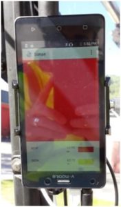
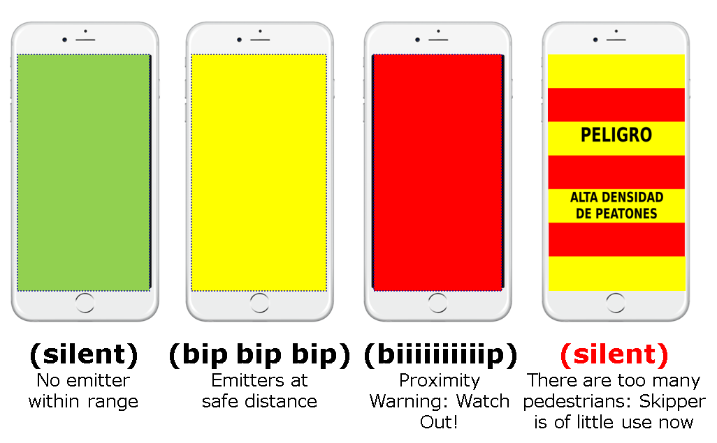
- A smartphone installed in the forklift detect sorrounding Bluetooth emitters, changing its color (green to yellow to red) and emitting a beep pattern that depends on the proximity of the nearest pedestrian.
- Skipper includes a 10W external speaker to make sure the beeps can be heard in a noisy environment.
- If the number of “red” pedestrians is too high, Skipper would remain in “red mode” continuously, thus being of little use. Instead, in that case Skipper indicates the driver that are too many pedestrians and remains silent until being useful again.
More information? Questions? Please write to info@rdnest.com.
Next-generation electronics for recycling bins: Sterling
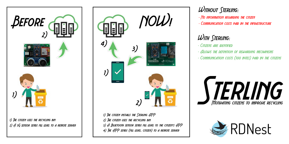
Sterling is a new concept in the development of IoT system for recycling bins. In addition to the classical measurement of fill level and other working parameters (temperature, humidity, battery level), Sterling is able to identify the user of the bin, allowing the development of tailored rewarding mechanisms to encourage recycling. To do so, Sterling takes advantage of Low Energy Bluetooth technology, that allows to link to a background service installed in the user’s smartphone.
Sterling offers three key advantages with respect to 3G/4G-based solutions:
- Much lower energy consumption, leading to a better autonomy time.
- Sterling allows to identify the user, allowing the development of rewarding mechanisms to encourage recycling.
- Sterling eliminates the need of having a SIM card in each recycling container. Sterling sends the information to the user, and it is the user who resend the information to the Internet, allowing to a great saving in running costs.
Sterling was officially presented to the Smart Cities community in SPIE 2018 International Conference:
STERLING: A framework for serious games to encourage recycling Ester Diego, David Carravilla, Guillermo Vicente, Hector Del-Campo Pando, Daniel Barba, Diego R. Llanos, Juan A. March. Proc. SPIE Remote Sensing, Volume 10793, Remote Sensing Technologies and Applications in Urban Environments III; 107930F (2018), DOI 10.1117/12.2325103, Berlin, Germany, sep. 2018. [PDF]
More information? Questions? Please write to info@rdnest.com.
Measuring water consumption: Pilgrim
Pilgrim is a complete solution developed by RDNest to measure water consumption in smart cities. Pilgrim is composed by two main elements:
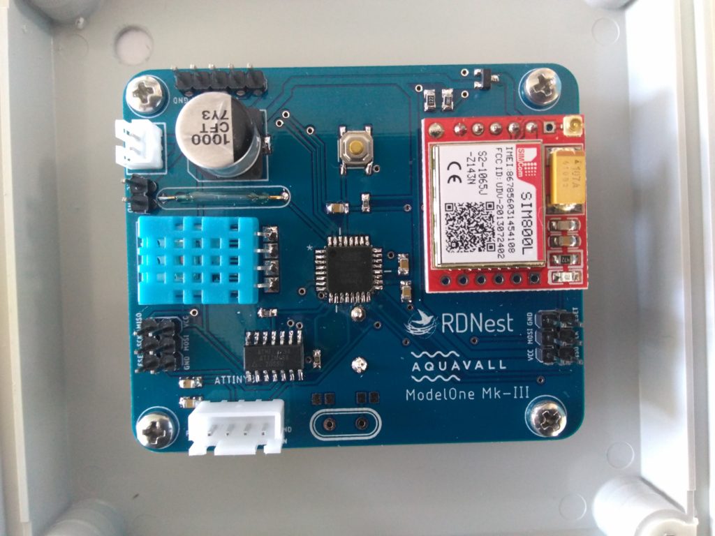
- A low-cost datalogger developed by RDNest (called ModelOne Mk3), that uses a lithium battery with several-years autonomy. ModelOne is remotely configurable, and uses 3G/4G communications to periodically send information regarding water consumption, as well as other measures (temperature, humidity, battery level, connectivity) to the Pilgrim server.
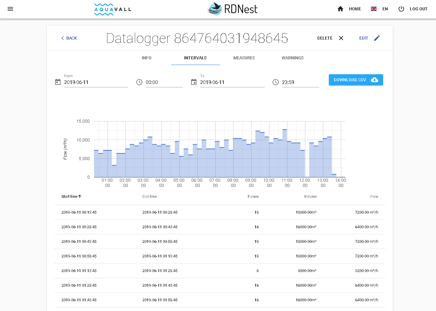
- Pilgrim is a cloud-based system that allows a complete management of a set of dataloggers, allowing to store and visualize all the information collected by them and to modify their configurations, thanks to a complete, web-based service.
The ModelOne Mk3 datalogger and the Pilgrim platform have been developed with support of the European Union through the FEDER Funds, managed by the Instituto de Competitividad Empresarial (ICE), for the development of R+D+i projects in Castilla y León, Spain.

More information? Questions? Please write to info@rdnest.com.
Indoor Positioning: XtremeLoc
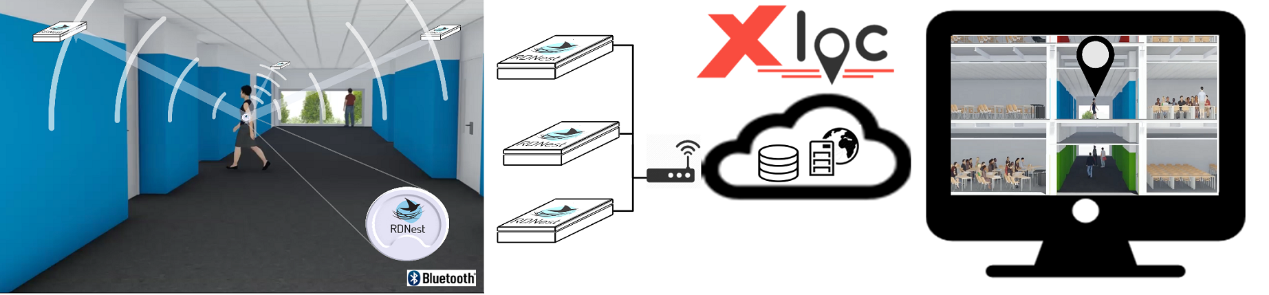
XtremeLoc is the solution offered by RDNest to the problem of Indoor Positioning and Tracking, to be used in situations where GPS-based solutions are either not possible or not affordable.
Our offer in the field of indoor positioning is based on the use of transmitters and receivers.
- Our solution uses low-power (4-years battery), small-sized (1.5 cm), low-cost transmitters, that can be carried by people or installed in equipments that the end-user want to be positioned.
- A network of low-cost RDHub receivers, with extended connectivity (WiFi, Bluetooth, Ethernet, 4G, 433MHz-band…) carefully deployed in the space to be monitorized, allows the positioning of people and assets with a one-meter precision, the highest precision available nowadays.
- Our RDView platform allows the positioning of each transmitter in the corresponding map in real time, together with the historical data stored by our servers. The same receivers deployment allow to complete this positioning information with environmental sensoring (CO2 levels, methane, temperature and humidity, existence of fire, etc). These features make our solution the best low-cost alternative for industry and health environments.
XtremLoc offer three different solutions:
Indoor Tracking.
Tracking of persons and assets using Bluetooth technologies.
![]()
In order to be located, persons and assets should carry either a Bluetooth emitter, or a smartphone with an APP that performs the same function.
The Bluetooth emitter we use (iBeacons) are low-cost elements, with a reduced size and volume, and with an autonomy measured in years.
Indoor Navigation.
Helping people to find their way inside an installation, thanks to a mobile-based APP.
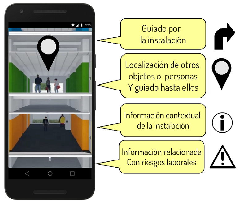
The very same infrastructure used to find persons and assets can also locate smartphones.
Our Skywalker APP uses this technology to guide the user to the person or good to be reached.
We can also configure other types of context-based information for specific applications, such as locating people in risk-managed environments.
Indoor Analytics.
Generation of statistical information on the movement of people or assets in facilities.
The storage of information of location of diverse elements making use of multiple technologies, allows to generate great amount of information.
This analysis is especially interesting in large facilities (stations) and shopping centers and allows to generate information on the most common itineraries, on access to restricted areas, on the most visited areas etc…
The analyzed information can help to define investments in subsequent infrastructures or to improve existing ones.
More information? Questions? Please write to info@rdnest.com.